
When UH graphic design professor Cheryl Beckett was approached to collaborate on “More City Than Water: A Houston Flood Atlas” in 2018, she challenged her design students to approach mapmaking as an expression of an idea rather than just an illustration of a surface-level wayfinding system.
The book— a compilation of essays, interviews and maps— provides a space for conversations about the impact of Hurricane Harvey on the city of Houston. Climate scientists, marine ecologists, housing activists, urban planners, artists, poets and historians all offer their thoughts on the city that has been increasingly affected by tropical storms.
It was a new concept for the seniors in the design program at UH. “As a design educator, it is critical to expose students to the role of graphic design as a strategy for reinforcing information that may get lost in statistics, jargon and layers of complexity,” stated Beckett.
One major goal of the book was to showcase climate inequities—how some neighborhoods are more prone to feel the impacts of major storms yet the least likely to receive aid and services to combat this vulnerability.
“There are many communities and neighborhoods that endure climate inequities that are not given a voice, and they need to be heard,” said Beckett. “This atlas offers some often-unheard voices, as well as unique perspectives that may propel ideas or inspire empathy in policy makers and urban planners.”
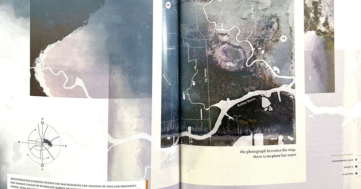
Students contributed individual maps which, through design, color, and detail, created a cohesive narrative throughout the book. One map was a waterlogged polaroid designed by Manuel Vazquez. It accompanied an essay entitled “The Only Thing You Have” by Lyric Evans-Hunter, a reflection on losing personal mementos in the flooding. Another chapter was entitled “Climate Dignity” in which color breaks in the mapmaking showed the inequities of storm-related resources.
Beckett herself contributed a visual essay to the atlas. After living through eight water events in Houston, “Ombrophobia” or “fear of rain” is Beckett’s depiction of the danger of rain told through a personal narrative.
One of the things that struck her as she gathered statistics about each storm was that each one, with its own set of nuances, forces a specific reaction—whether through policy or infrastructure. Evacuation routes, attempting to clean up the toxicity of areas of the city, even the “Turn Around, Don’t Drown” campaign all came out of the devastating events Houston has endured. Over time, the solutions seem to be increasing in scale and expense— like the proposed Ike Dike or the eight massive storm water tunnels, for example.
Beckett is proudest of her students for their growing awareness through their research of some of the issues that define the city. She also applauded the stunning designs, which incorporate embedded symbolism along with watercolor surfaces that ranged from blue to more toxic colors to represent flooding and seepage.
“My students had to be abstract and expressive, but also had to be accurate,” said Beckett. “It was crucial that the maps told the story.”
More City Than Water, edited by Lacy Johnson, professor at Rice University and director of the Houston Flood Museum, is available at University of Texas Press.
University of Texas Press/More City Than Water: A Houston Flood Atlas/Edited by Lacy M Johnson and Cheryl Beckett/Manuel Vazquez
